Victorian Ordnance Survey: Sheet No. 18 - Beverley (Bridlington, Great Driffield)
by Ordnance Survey
On This Page
Description
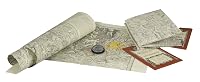
This series offers reprints of the first edition of the one-inch Ordnance Survey maps of England and Wales, dating from 1805 to 1900. Detail includes villages, hamlets, farms, county boundaries, roads and railways.Tags
Members
- Recently Added By
Author Information

2,168+ Works 20,317 Members
Classifications
Statistics
- Members
- 2
- Popularity
- 6,025,901
- Languages
- English
- ISBNs
- 1