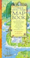
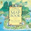
The Once Upon a Time Map Book
by B. G. Hennessy
On This Page
Description
Visit six imaginary lands, follow maps and directions, and find hidden treasures.Tags
Recommendations


Member Reviews
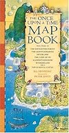
This book provides maps for tours of six enchanted lands. Fly to Neverland with Peter Pan, skip down the yellow brick road with Dorothy, fall down the rabbit hole to Wonderland, climb the beanstalk to the Giant’s kingdom, see the sights at the market in Aladdin’s kingdom, and enjoy the lush greenery of the Enchanted Forest where Snow White and the seven dwarves live. Can you follow the directions to navigate your way through each of the six lands? Can you avoid all the perils and find all the hidden objects?
Hennessy and Joyce have created a playfully illustrated book to help kids practice map reading. Each map is set against an quadrant grid (can you find the Jolly Roger at A4?) and a compass to provide directional context is placed show more in the corner. Readers must consult the key to figure out how long a munchkin mile is and how to recognize the pebble road as compared to the yellow brick road. Points of interest are featured, as well as warnings about dangers to avoid and items to find hidden in the map. The text, especially the map directions, is descriptive and utilizes a wide vocabulary. The illustrations are detailed and intentionally busy in places. Each map is rendered in a similar style, but in a different color palate. For instance, Aladdin’s kingdom uses a palate of yellows, oranges, and reds, while Wonderland is a combination of grass green and red brick.
Full Review at Picture-Book-a-Day: http://picturebookaday.blogspot.com/2012/08/book-215-once-upon-time-map-book-by-... show less
This is a clever resource to use in order to introduce young readers to the format and process behind using a map including directions as well as the breakdown of a map in regards to longitude and latitude. The maps that children are looking at aren't normal maps, but rather, fairytale lands. Children are able to learn about how maps work while diving into the layout of their favorite fairytale land! This is a perfect way to help children find interest in what they are reading, all while learning.
Nothing about the presentation pleased me. The map of Peter Pan's Neverland was not really congruent w/ the book.
Ratings
Members
- Recently Added By
Lists

Lost ::: Mapping Tales for Kids
33 works; 2 members
Author Information

58 Works 11,196 Members
Common Knowledge
- Original publication date
- 1998
- Important places
- Neverland; Wonderland; Aladdin's kingdom; Enchanted Forest; Giant's kingdom; Land of Oz
Classifications
Statistics
- Members
- 312
- Popularity
- 101,996
- Reviews
- 3
- Rating
- (3.72)
- Languages
- English
- Media
- Paper
- ISBNs
- 11
- UPCs
- 1